East Finchley Walks
 This
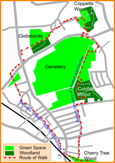
walk from East Finchley station follows the ancient track which led
along the edge of the common. Turn left out of the station and make
your way round the back of MacDonalds HQ.
150 years ago we would have left the High Road at the Mutton Brook and cut diagonally across the Dirthouse field and East End Road to Market Place, formerly Hog Market. On the left were shops, Prospect Place (1825) and the George public house. To the right was open field as far as the High Road, and Chapel Street, since lost in the redevelopment. Facing us, where the road swings right was a triangular green in front of a row of houses on the Pound. All this is now incorporated into the shrubbery and children's playground.
Continuing through the playground we pass first to our right the site of the Post Office, then a field and an imposing row of cottages to the left. Past the Constitutional Club the path becomes the Walks and swings leftish across the former grounds of Park Gate towards what was the triangle at the bottom of Church Lane, formerly Bull Lane. The southern leg of this triangle, just before the Windsor Castle pub, has disappeared. To the right was the common. The route continues along King Street and a short passage to the Red Lion pub on Red Lion Hill, an original settlement called Cuckolds' Haven. Between road and passage was the Methodist chapel and school.
Take the left path up to Oak Road along the edge of the housing estate. When the road bears right, follow the old path straight on in front of the new housing development. Before it was even a Lucas factory site, there were two large houses, Oak Lodge and the even grander "Grange", built for Edward Sayer a well known East Finchley resident. Follow Tarling Road and the narrow path to the foot bridge across the North Circular Road. Here the route is blocked and we follow the NCR eastwards to cross the High Road by the Territorial Army hall. South of the intersection can be seen the location of what was the only settlement on the common itself, Brownswell, where the Strawberry Vale Brook flowed east to form the northern boundary of our parish.
Start of 'The Walks' looking north, with Constitutional club on left. Our route passes the glebe lands, possibly the last remaining fragment of the common. Take the path along the edge of the fields to Summers Lane, then right to pick up Nursery Approach at the end of which is Coppetts Wood, marking the Eastern edge of Finchley and the Common. Turn south along the former northern part of Coppetts road before the NCR development, then cross the footbridge to join present day Coppetts road. Before Trott Road, turn right into the track leading to the sports ground. The fence along the right of the field marks the boundary of Anglo Saxon Finchley and the old Common, only formally agreed with Hornsey in 1816. If you spot a small cast iron boundary marker, marked FP for Finchley parish, let the Archer know. Continue up through the coppiced hornbeam of Coldfall Wood and exit at the south west corner into Creighton Avenue, cut through the wood in 1899, which at that time stretched to Fortis Green. The old boundary, marked by poplars, continues between the gardens of Church Vale and Durham Road. Take the passageway into Durham Road, then to Summerlee Avenue, crossing the old boundary of the Bishops Park into Cherry Tree Wood and back to the station.
